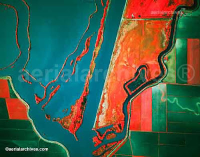
 Infrared aerial photography use infrared film and digital sensors, which are sensitive to a certain portion of the light spectrum. Infrared aerial photography is important for monitoring structures or objects that give off unique heat signatures. This map shows vegetation, and one can easily notice the farms to the right, whose different crops give off different heat signatures. This map is also hypsometric. This map could also serve as a thematic map if a proper key could be established linking color to vegetation type.
Friday, April 23, 2010
Infrared Aerial Photography
Infrared aerial photography use infrared film and digital sensors, which are sensitive to a certain portion of the light spectrum. Infrared aerial photography is important for monitoring structures or objects that give off unique heat signatures. This map shows vegetation, and one can easily notice the farms to the right, whose different crops give off different heat signatures. This map is also hypsometric. This map could also serve as a thematic map if a proper key could be established linking color to vegetation type.
Subscribe to:
Post Comments (Atom)
No comments:
Post a Comment