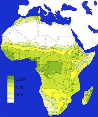
 Isohyets are lines that connect equal areas of RAINFALL on a map. This map shows the rainfall levels on the continent of Africa using isohyets. Notice the lack of rainfall in the north due to the dry desert climate. This map is also planimetric, chloropleth, thematic, and an isoline map.
http://images.google.com/imgres?imgurl=http://www.artsci.wustl.edu/~anthro/courses/306/precip.GIF&imgrefurl=http://artsci.wustl.edu/~anthro/courses/306/geography.html&usg=__a1VebgNSEhskKHyPYyzATaLRDnY=&h=566&w=475&sz=43&hl=en&start=10&um=1&itbs=1&tbnid=u4HZDdDqIWGSBM:&tbnh=134&tbnw=112&prev=/images%3Fq%3Disohyets%26um%3D1%26hl%3Den%26gbv%3D2%26tbs%3Disch:1
No comments:
Post a Comment